 Geobru catalogue
water table
Type of resources
Available actions
Topics
INSPIRE themes
Keywords
Contact for the resource
Provided by
Formats
Representation types
Update frequencies
Scale
-
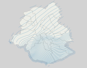
Brussels-Capital Region: piezometric maps (May 2013) for the following aquifer (and aquitard) hydrogeological units : - UH/RBC_1 Quaternary aquifer system: US/RBC_14 Silts, sands and alluvial gravels ; - UH/RBC_2 Perched sandy aquifer system (Diest Fm, Bolderberg Fm, Sint-Huibrechts-Hern Fm and Onderdale Member); - UH/RBC_4 Aquifer system of the Wemmel, Lede, Brussels and Vlierzele sands (or better known as the Bruxellian sands); - UH/RBC_6 Aquitard of Tielt sands and clays ; - UH/RBC_7 Kortrijk Sand and Clay Aquitard System (Moen Member); - UH/RBC_8 Aquifer of the Landénien sands. The piezometric levels (in m-DNG/TAW) are represented by piezometric lines separated by a 2m step. These data are limited to the borders of the Brussels-Capital Region extended by a 500m buffer zone. The piezometric maps of UH/RBC 1 to 7 are from Brussels Phreatic System Model v1.0 (BPSM v1.0) and that of UH/RBC 8 is from Hydroland v1.0. These two hydrogeological models were developed under FEFLOW 7.1 and 6.1 ® respectively. del. This data is generated from models and may contain errors, inaccuracies and gaps. It has informative value and may under no circumstances replace a study carried out by an expert. Bruxelles Environnement cannot be held liable for the consequences of the use of this information.
-
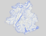
Brussels-Capital Region: Map of the absolute piezometric phreatic levels (May 2013) obtained with the combination of the piezometric levels of the following hydrogeological units of the Brussels phreatic system: - UH/RBC_1 Quaternary aquifer system: US/RBC_14 Silts, sands and alluvial gravels ; - UH/RBC_2 Perched sandy aquifer system (Diest Fm, Bolderberg Fm, Sint-Huibrechts-Hern Fm and Onderdale Member); - UH/RBC_4 Aquifer system of the Wemmel, Lede, Brussels and Vlierzele sands (or better known as the Bruxellian sands); - UH/RBC_6 Aquitard of Tielt sands and clays ; - UH/RBC_7 Kortrijk Sand and Clay Aquitard System (Moen Member); This map thus includes the absolute piezometric levels of the most superficial aquifer units, in order to map the level of the "piezometric groundwater surface". The piezometric levels (in m-DNG/TAW) are represented by level lines (isopiezes) separated by a 2m step. These data are limited to the borders of the Brussels-Capital Region extended by a 500m buffer zone. These data are extracted from the Brussels Phreatic System Model v1.0 (BPSM v1.0) hydrogeological model, developed under FEFLOW 7.1 ®. This data is generated from models and may contain errors, inaccuracies and gaps. It has informative value and may under no circumstances replace a study carried out by an expert. Bruxelles Environnement cannot be held liable for the consequences of the use of this information.
-
Brussels-Capital Region : data on the 5 Groundwaterbody of the Area of Brussels, defined under the Directive and the Ordinance Water : code European, code of Brussels and name of the water mass, hydrographic district
-
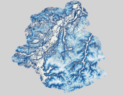
Brussels-Capital Region: map of the depth of the piezometric phreatic levels (May 2013) obtained with the combination of the piezometric levels of the following hydrogeological units of the Brussels phreatic system: - UH/RBC_1 Quaternary aquifer system: US/RBC_14 Silts, sands and alluvial gravels ; - UH/RBC_2 Perched sandy aquifer system (Diest Fm, Bolderberg Fm, Sint-Huibrechts-Hern Fm and Onderdale Member); - UH/RBC_4 Aquifer system of the Wemmel, Lede, Brussels and Vlierzele sands (or better known as the Bruxellian sands); - UH/RBC_6 Aquitard of Tielt sands and clays ; - UH/RBC_7 Kortrijk Sand and Clay Aquitard System (Moen Member); This map thus includes the relative piezometric levels of the most superficial aquifer units, in order to map the depth of the "piezometric groundwater surface". The piezometric levels (in metres from the topography) are represented by level lines (isobaths) separated by a 2m step. These data are limited to the borders of the Brussels-Capital Region extended by a 500m buffer zone. These data are extracted from the Brussels Phreatic System Model v1.0 (BPSM v1.0) hydrogeological model, developed under FEFLOW 7.1 ®. This data is generated from models and may contain errors, inaccuracies and gaps. It has informative value and may under no circumstances replace a study carried out by an expert. Bruxelles Environnement cannot be held liable for the consequences of the use of this information.